|


|
|
This web has
been visited
times
|
|
  |
|
|
Project Description |
|

 |
| |
This project deals with the numerical simulation of four important environmental problems: the realistic prediction of wind fields, solar radiation, air pollution and forest fires. Improvements to the physical-mathematical models, that we have developed in previous coordinated projects (between Universitat Politčcnica de Catalunya, Universidad de Salamanca and Universidad de Las Palmas de Gran Canaria), are proposed. Specifically, we will study new alternatives for (a) horizontal interpolation and vertical extrapolation to obtain the initial wind field velocities, (b) the modelling of pollutant emissions and non-linear chemistry, (c) the extension to two layers and non-local diffusion models for forest fires and (d) an adaptive solar radiation model considering the beam, diffuse and reflected radiation, as well as the effect of terrain shadows.
|
|
 |
|
|
 |
|
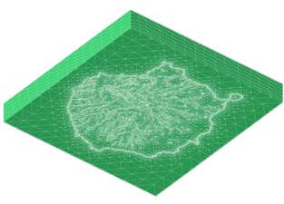
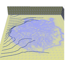
In addition, advanced numerical techniques such as discontinuous Galerkin schemes for convection-diffusion-reaction problems, domain decomposition, space-time adaptive techniques, time integration schemes for non-linear reaction models, parameter estimation with genetic algorithms and parallel computing, will be considered. Besides, a new 3-D mesh generation method and innovative mesh optimization techniques will be developed. By using these new methods, we will implement a robust code for automatic construction of meshes for environmental problem simulation within a user-friendly framework. The main objective of the project is the combination of our local approaches with predictive mesoscale models such as MM5, WRF or HIRLAM for weather, and CMAQ or MOCAGE for air quality. These models usually solves the problems by using finite difference methods on an structured grid (defined on several nested domains) and can predict atmospheric magnitudes with a maximum resolution about 1 Km. The combination of these predictive models with our adaptive finite element models, which work with triangular or tetrahedral unstructured meshes, will allow us to carry out predictive simulations in a local scale accurately (about a few meters). In this way, the terrain characteristics and solution will be efficiently approximated according to a desired precision. Finally, the use of Geographic Information Systems (GIS) in the models will be crucial in order to tackle realistic simulations.
|
|

|
|
|
|
|
Latest Update:
21/12/2011 |
|